
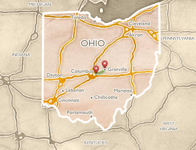
Granville
 ABOUT THE ROUTE
Granville is an exquisite town, founded by New Englanders eager to create an environment that would help them feel at home. Broadway has fine architecture, perhaps most notably the Greek Revival masterpiece Avery-Downer House (open to the public), and a charming small-town ambience, plus good shops and cafés. There are beautiful churches, including at least one in a proper “New England” mode. Two wonderful historic inns are available to use as a base for visiting central Ohio. Granville is also the home of Denison University: meandering drives and imposing academic architecture occupy the prominent hilltop above the village. The town has its own earthwork (the distinctive, so-called “Alligator”), and is also directly adjacent to the great earthworks at Newark (see Newark itinerary).
Arrive in Granville from I 70 via the SR 37 exit (SR 37 is coming up from Lancaster), or from Columbus via Broad Street (SR 16) or the new, four-lane SR 161 through New Albany.
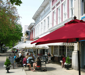
Broadway in Granville, blends the ambience of a New England village, a college town, and an old Midwestern Main Street.
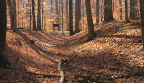
 ALLIGATOR EFFIGY
Just outside town to the east is the “Alligator” Effigy, the greatest animal effigy in Ohio after Serpent Mound. Now preserved by the Ohio Historical Society, it is accessible from the old Newark-Granville road: take Broadway heading east, and after about a mile enter the subdivision called “Bryn du Woods” on the left and follow the street as it curves to the left and climbs to the hilltop. The effigy lies atop the cul-de-sac at the end, and is best seen in very early or very late sunlight when the shadows are deep. The beautiful views (now between large houses) from this hilltop extend westward to open plains beyond Granville, and eastward into the defined valley terraces across which the Newark Earthworks were laid out. The builders of the effigy no doubt appreciated these relationships, the prominence of this spot in encompassing the dual ecologies, and especially the nearby geometric earthworks which were already 800 years old when this effigy was begun.
The earthen creature with four rounded feet and a long, curling tail became known to early settlers as the “alligator” but there are more likely possibilities. It may be the “underwater panther,” a powerful creature of the watery underworld, believed by Indians to have dark and dangerous powers, and a long tail that could unleash canoe-swamping whirlpools. A mysterious fifth appendage was an elevated, stone-covered circle, coming out of the animal’s side, where many fires burned.
How would a four legged effigy creature in Ohio, with a curly tail, end up with the improbable name of “Alligator”? Dr. Brad Lepper explains one possibility, based on his research of Indians’ of oral traditions of the “underwater panther”:
We certainly know that Native Americans and European American pioneers lived at the same time in the Granville area. Well, what if one of those pioneers had asked a Native American what that was? And if that Native American used their own term – the Ojibway term is “Mishewayshee,” for Underwater Panther – and the European is still struggling with the language, and it’s like “underwater panther? Panthers don’t live underwater; what do you mean?” And if the Native American had said, “that spirit, that creature that lives in the water with a long tail and sometimes eats people,” the European would have said, “Oh you mean an alligator!”
From the effigy, or from the heart of Granville, there is easy access to the four-lane highway SR 16, leading east into the city of Newark (see Newark page), or west (turning into SR 161) to Columbus.
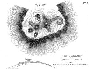
The Alligator as drawn by Squier and Davis in 1848, showing the heavily burned “altar” area emerging from the torso.
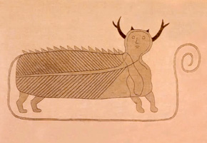
This drawing of the mythical “Undewater Panther” illustrates its curling tail, also present on the effigy mound.
 OHIO HISTORY CONNECTION
The short drive from Granville into the city of Columbus is rewarded with a thriving arts and cultural scene, the Ohio State University, and the Ohio History Center, home of the Ohio History Connection with its collections, exhibits, shops, and offices. The OHC exhibit is an essential complement to any earthworks tour, as it presents many of the finest artifacts in existence from the earthwork-building cultures, such as the Newark Shaman, the Adena Pipe, the mica hand, many effigy pipes, and huge obsidian ceremonial blades. The center is located just west of the 17th Avenue exit on I 71, north of downtown Columbus.
An exhibit here presents the UNESCO World Heritage “Hopewell Ceremonial Earthworks” and an innovative presentation of some of the spectacular artifacts from the OHC’s extensive collections.
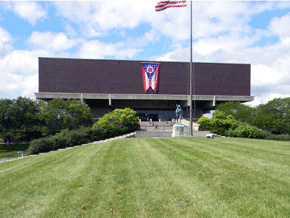
The Ohio Historical Society’s exhibits are located in a massive concrete cube from the “brutalist” 1970s, though thanks to a recent renovation it is pleasant inside.
 HISTORY OF THE OHIO HISTORICAL SOCIETY
It was in 1805 that a group of dedicated individuals founded the “Ohio State Archaeological and Historical Society.” The national importance of Ohio’s earthwork sites had already become well known, through publications like Squier and Davis’s Ancient Monuments of the Mississippi Valley. Indeed the growing fame of these places was creating a problem. Retired Curator Martha Otto explains:
There were some eastern Universities like Harvard, and so forth, that were sending people out here to investigate the mounds, and they were taking collections back to their respective locations. So one of the reasons why the organization was founded was to have some sort of body, within the state of Ohio, that would do archaeological research and maintain the collections.
Soon the Society was chartered by the state, and began in earnest its stewardship of Ohio’s historic and ancient places:
In the 1890s, the organization started acquiring archeological sites like Fort Ancient, and around 1900 we acquired Serpent Mound from the Peabody Museum. And from then on it was a matter of acquiring various archaeological and historical and natural sites throughout the state that were deemed to be particularly significant.
In the 1950s, the word “archaeological” was dropped from the name; and in the 1970s, the massive new museum was put up. Now renamed the Ohio History Connection, the organization partners with other groups around the state to maintain, administer, and interpret the earthwork sites under its purview.
 THE OHIO STATE CAPITOL BUILDING
In the heart of downtown Columbus, on Capitol Square, the Statehouse was begun in 1839. Its cupola was modeled on the circular Tholos of Delphi, then recently discovered in Greece. It preserves in its lower level (the walls downstairs, around the gift shop) the visible rubble footers that were taken from the Mound Street Mound, as was the clay to make many of the bricks in its inner walls. A huge mural in the rotunda depicts the Treaty of Greeneville, which forced Indians to give up their claims to much of what is now Ohio.

The Ohio Statehouse is a good example of Greek Revival monumental architecture, reflecting the democratic idealism of the time.
 THE OHIO STATE UNIVERSITY
Lively urban districts and historic residential neighborhoods now stretch continuously from downtown Columbus (along High Street) both southward (to the German Village) and northward to the huge campus of The Ohio State University, Ohio’s premiere flagship research university with renowned departments in many disciplines, including Ohio archaeology. The campus is also home to the world-famous Wexner Arts Center (with changing exhibits) designed by Peter Eisenman in the 1980s.
 SHRUM MOUND
The Shrum Mound in Campbell Park (5 miles northwest of downtown Columbus, about ½ mile south of the intersection of McKinley Avenue and Trabue Road) is a well-preserved, 20-foot tall, conical mound.
It is one of the last ancient mounds left in the Columbus area, named after the family that donated it to the Ohio Historical Society. Its conical form and isolated position suggest an Adena era burial mound, although there have been no archaeological investigations.
This tranquil park, named for former Ohio governor James E. Campbell, is surrounded by a gigantic old limestone quarry on one side, and rushing road traffic on the other, suggesting how close the mound came to being destroyed. Yet it remains, in this improbable spot, a direct link to the distant past. Climbing the steep path to the 20-foot summit, you can feel, as one visitor wrote, that “it’s still a haunting place.”
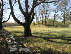
The Shrum Mound sits in the center of a tiny park, rimmed with a low, symmetrical, stone wall, at the edge of an immense quarry.
 HIGH BANKS METRO PARK
In the High Banks Metro Park just north of the city (entrance on North High Street (US 23), 2½ miles north of Interstate 270), two mounds associated with the Adena culture and a semi-circular earthen enclosure lie atop a 100 foot cliff overlooking the Olentangy River. The enclosure, also called the Orange Township Works, can be reached by trails from the Nature Center (with interpretive exhibits) at the park.
The “High Banks” name comes not from the ancient Indian earthwork, but from the 110-foot, exposed shale precipice rising above the Olentangy River. The cliff and the earthwork are reached by the 2.3-mile Overlook Trail through dense woods, across steep ravines, and past a preserved cemetery plot.
The trail passes through the ancient earthwork, together with its watery outer ditch (where salamanders breed). It was designed to encircle the promontory, and a long extension of the wall is visible to the north and west. It diminishes on both sides, along the steep-sided ravines. This 1500-foot earthwork probably marked a village boundary, between 8 and 14 centuries ago.
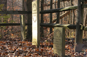
A small cemetery along the Overlook Trail in High Banks Metro Park preserves exquisitely carved headstones.
Near the spot where the trail passes through them, the earthen wall and ditch are especially prominent.